The challenge of cross-sensor geometric alignment
- Jun 11
- 2 min read
Many NewSpace missions place several instruments on a single satellite. Using multiple identical instruments, like VNIR pushbroom cameras, you can increase the effective swath width. If you use different instruments together, you can collect more types of data from the same place at once.
It is difficult to align these sensors perfectly.
Why is geometric alignment difficult?
Earth observation satellites rely on two types of sensors to geolocate imagery on the ground. GNSS (such as GPS) for the satellite's position, and a variety of sensors, like star trackers, sun sensors, and magnetometers, for the satellite's orientation.
While travelling at 8 km/s, 500 km from Earth's surface, even the smallest inaccuracies in timing, positioning, and orientation can lead to large geolocation errors.
To derive the most value from multiple instruments on the same satellite, you need to position the data on top of each other with extreme accuracy.
How do we do geometric alignment?
FarEarth has developed several strategies to achieve sub-pixel alignment of satellite imagery. Position and orientation information alone are insufficient to geolocate each pixel. We often rely on additional, external reference data, to precisely align imagery. The process is similar to band alignment, with the complexity of timing differences between instruments and physical variations due to temperature fluctuations.

Two strategies for geometric alignment.
One can independently align the image data to the reference data. Then combine them in a final resampling to a single product. Alternatively, align the imagery with each other first. Then refine the geolocation to reference data as a final step.
Which strategy to use depends on several factors such as:
the intended application of the imagery
the difference in resolution between the sensors
the stability of the physical relationship between instruments
how well the imagery correlates with each other
how well the imagery correlates to reference data
if there is an overlap between the imagery
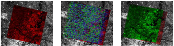
For two VNIR sensors arranged side by side, it may be easier to align their data first, because the correlation between the sensors is usually high. Note: the overlap may be too small to identify enough salient features.
When aligning TIR and VNIR sensors, it is difficult to find matching features between the sensors due to spectral differences. With good overlap, there may be enough features to overcome this problem.
Successful geometric alignment is the key to unlocking analytics and improving coverage for mission operators.