Orthorectification and off-nadir angles explained
Updated: Jul 30
NewSpace Earth observation satellites are usually agile, which means that the camera does not always look straight down but can point sideways. This increases the possible areas you can capture in-orbit. Small satellite images are often acquired at an angle. In such images, you will not just see the roof of a tall building, for example, but also some side views.
Orthorectification
To make satellite imagery usable, you need to remove the tilt so that it can be projected on a map. The goal is to change the image so that it appears as if the satellite was looking straight down (nadir). This makes it easy to compare different images at different angles and different timestamps.
The process of correcting this off-nadir view is called orthorectification. You need to make corrections for the sensor tilt, curvature of the Earth, and, very importantly, topographic relief. To correct for topographic relief, a known 3D terrain model is used to calculate elevation.
Imagine the satellite is acquiring an image of a pyramid. At nadir, all sides of the pyramid appear equal. Off-nadir, some sides of the pyramid appear larger.

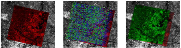
Below is an example of an actual image taken of a mountainous area close to Innsbruck. You can see the image before and after orthorectification. Note how the edges of the scene warp when the viewing angle is corrected to nadir.

What does this mean for image quality?
In most cases, if the incident angle is not too high, scientific orthorectification will correct your image so that it is indistinguishable from an image taken at nadir. If the angles are high, it will, however, affect the quality.
A camera consists of many detectors. Each detector captures light from a small area on Earth. This view of the detector is called the instantaneous field of view (IFOV). This light measurement is translated into a single pixel of the image.
When the camera looks sideways, each detector views a larger area on Earth. This means that off-nadir images have a larger ground-sampling distance (GSD), which means the image becomes less sharp.
For example, the distance to a target increases by roughly 16% when viewed at an off-nadir angle of 30°. Therefore, there is a 16% increase in GSD.

Let’s look at the pyramid drawing below. The image on the left shows the satellite image acquired off-nadir. (As you can see, the pyramid has been painted with symbols😉). After orthorectification, the corrected image looks like the picture on the right.
Before correction, the yellow side of the pyramid is only 1 pixel wide. After orthorectification, the yellow side is 2 pixels wide.
Notice how the painted symbols have been correctly elongated. If a pixel is elongated, it will start to look smeared, simply because there is not enough pixel information to complete our picture.

There are other limits to orthorectification. For example, if the satellite is looking at a very tall building at a steep angle, the road behind the building may not be visible at all. Even after orthorectification, the road will not magically appear.
It is not only the size of the pixels that is affected by off-nadir viewing. Consider that the distance between the camera and the area viewed on Earth increases when looking at an angle. The camera is therefore looking through more atmosphere, which attenuates the light reaching the camera. This affects the radiometry, which again needs to be corrected for bottom-of-atmosphere products.
It is important that the end product captures viewing angles and applied corrections in the metadata so that downstream users can decide where the images are useable for their specific applications.
If you want to process your raw Earth observation imagery automatically, consistently, and at scale for reliable production delivery, contact us about FarEarth.